| |
|
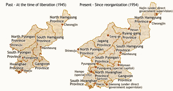
 Territory
 |
| North Korea occupies territories north of the
military demarcation line as stipulated by the ceasefire
agreement of July 1953 that ended the Korean War.
According to South Korea Constitution, which states
that the national territory includes the whole of
the Peninsula and surrounding islands, North Korea’s
territory legally belongs to South Korea but is
being ruled by North Korea. |
| Coordinates |
124˚18´41˝to 130˚41´32˝ East / 37˚41´00˝
to 43˚00´36˝North |
| Area |
122,762㎢ (55% of 222,300㎢, total area of
the Peninsula and surrounding islands) |
| National
Borders |
1,369.4㎞ (China 1,353.2㎞, Russia 16.2㎞)
|
| Coastline
Length |
2,495㎞ (Total coastline length of the Peninsula
is 8,593㎞) |
|
|
 |
|
|
Geography |
Elevation is high in the northern and eastern
regions, gradually leveling out toward the southern
and western regions. Part of the Baekdu Mountains,
the Nangrim Range spreads from the north to the
south, from which the Gangnam, Jukyuryung, Myohyang,
Uhnjin, and Myulak Ranges sprout to the west.
The Hamgyung and Boojunryung Ranges encompass
the North and South Hamgyung Provinces, eventually
meeting with the Nangrim Range. Rivers originating
from these mountain ranges flow to the East and
Yellow Seas, forming flatlands in the western
regions. |
| Major
Mountains and Peaks |
Mount Baekdu (2,750m), Gwanmo Peak (2,540m),
Mount Buksubaek (2,521m), Mount Nampotae (2,433m).
There are some 50 mountains and peaks with
elevations higher than 2,000m. |
| Major Plateaus |
Plateaus of high elevations have been formed
to the north of regions connecting North Pyongan
Province’s Myohyang Mountains and South Hamgyung
Province’s Hamheung city. The ten main plateaus
include the Baekmu, Gaema, Jangjin, Nangrim,
and the Poongsan. |
| Major Basins |
Hweryung, Gangge, Goosung, Dukchun, Echun,
etc. |
| Major Rivers |
Rivers flowing westward are long and winding
- some major rivers are the Abrok (Yalu),
Daedong, Chongchun, Yesung, etc.
Rivers flowing eastward are short and straight
- some main rivers are the Duman (Tumen),
Namdaechon, Yongheung, Uhrangchon, Sungchun,
etc. |
| Major Plains |
Flatlands are located mainly in the western
regions.
Pyongyang Plains (950㎢, drainage of middle
and southwest parts of the Daedong River),
Jaeryung Plains (1,300㎢, includes South Hwanghe
Province’s Jaeryung, Shinchun, Ahnak, and
Eunchun; drainage of the Jaeryung River),
Yonbaek Plains (1,150㎢, includes South Hwanghe
Province’s Yonahn, Baechun, and Chungdan regions),
Yoldoo Samchunri Plains (750㎢, includes South
Pyongahn Province’s Ahnju, Moonduk, Sookju,
and Pyongwon regions; drainiage of the Chongchun
River), Hamheung Plains (includes South Hamgyung
Province’s Hamju and Jeungpyong regions; drainage
of the Sungchun River), Yongchun Plains (drainage
of North Pyongahn Province’s Abrok [Yalu]
River) |
| Major Lakes |
Soopoong (298.2㎢), Woonbong (104.9㎢), Jangjin (46.1㎢), Bujeon (20.3㎢), Suheung, etc. (some
25 lakes are broader than 5㎢) |
|
|
|
|
|
Climate |
Although North Korea is located in a temperate
zone, winters are cold while summers are hot due
to the influence of the continental climate. The
average temperature of the Peninsula throughout
the year is 10℃. By region, yearly average temperatures
are 14∼15℃ in the south, 10℃ in the middle, and
3∼6℃ in the north. Therefore, the temperature difference
between summers and winters in North Korea is significant.
The temperature difference is also great within
different regions of the country. The yearly average
temperature of Hesan is 3.6℃ while that of Haeju
and Wonsan is 11℃. This temperature difference becomes
greater during the winter. The average January temperature
of Wonsan is -2.5℃ while that of Hesan is -16.6℃,
resulting in a differences of almost 14℃.
North Korea’s winters, lasting for five months,
are almost a month longer than those of the South.
Naturally, North Korea’s rivers remain frozen for
a longer durations. (Duman [Tumen] River: 4 months,
Abrok [Yalu] and Daedong Rivers: 3 months)
In contrast, regional temperatures do not vary substantially
during the summer.
Average yearly rainfall in North Korea is 600㎜∼1,500㎜.
Although on average, less rain falls in the North,
it resembles South Korea in that 53~63% of total
rainfall is concentrated during a three-month
period from June to August. Rainfall varies by
region within North Korea. The yearly average
for the Jangjun (Gangwon Province’s Gosung County)
area is 1,520㎜, while that for Hesan is only 606㎜.
|
|
|
|
|
Natural Resources |
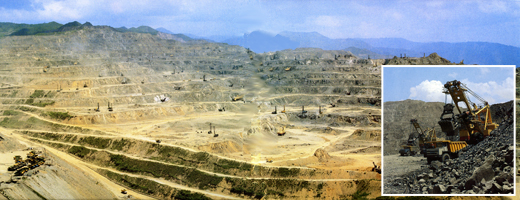 |
| A
Subterranean Resource Mine in North
Korea |
|
|
Major ores include: molybdenum, magnesite, graphite,
barite, mica, fluorite, silver, steel, lead, zinc,
aluminum, coal, etc. The numerous geological layers
formed during the Archaeozoic to the Cenozoic eras
and frequent diastrophism have endowed North Korea
with plentiful mineral resources.
Lead and zinc are major components in North Korea’s
export industry. Some major mines include the Gumduk
Mines in South Hamgyung Province’s Danchon region,
the Yang-gangdo Mines, and 20 others.
Almost half of the world’s total magnesite deposits
are located in North Korea, especially in the vicinity
of Danchon County.
Coal, one of North Korea’s key energy sources, is
deposited plentifully throughout the nation. Most
of the coal is anthracitic. Bituminous coal deposits
are mainly located in North Hamgyung Province’s
Aoji and South Pyongan Province’s Anju regions.
Although North Korea is believed to have subterranean
oil reserves, their profitability has yet to be
established. Foreign oil companies have conducted
numerous, yet fruitless, explorations for oil fields
in North Korea. |
|
|
 |
|